Precise measurements can make a difference between 15% and 45% profit margins in landscaping projects. Our professional experience shows that traditional landscape measuring tools often result in estimation errors that get pricey due to inaccurate bids.
Modern land measurement tools have altered the map of our industry’s efficiency. AI-powered measurement software cuts estimation time by 90%. High-resolution GIS imaging provides detail down to 3 inches per pixel. These advancements help us deliver more precise results than ever before. The right measurement tools are vital to your success, regardless of whether you handle small residential projects or large commercial properties.
This post will help you discover the most practical landscape measuring tools we’ve tested personally. Our analysis ranges from simple tape measures to advanced motion-based devices that measure distances up to 300 meters. You’ll learn which tools best match your specific needs and budget.
Traditional Landscape Measuring Tools: Tested for Accuracy
Premium traditional measuring tools have built a solid reputation by delivering reliable and consistent performance in landscape measurements. Let me share the best tools we’ve tested in the field.
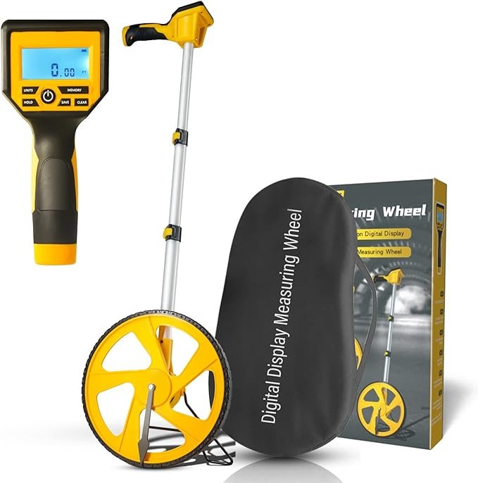
Measuring wheels: When and where they excel
Measuring wheels, first introduced in the 1600s, are great at covering long distances fast. These wheels become invaluable to measure driveways and yard boundaries on properties with large acreage. The wheel size plays a key role in accuracy – smaller wheels (4-6 inches) work best indoors, while larger ones (15+ inches) suit agricultural and land management tasks better.
Surface conditions can affect measurement accuracy. These tools work best on smooth surfaces like pavement, though rough terrain makes them bounce and reduces precision. You can boost accuracy on uneven surfaces by using a string line with the measuring wheel. Newer models include a digital display to make it easier to track your work.
Tape measures and their limitations
Steel tape measures remain vital to detailed measurements up to 33 feet. They have fewer potential failure points due to their simple mechanics and are ready to use without power. Steel tapes give better accuracy than fiberglass ones, especially when you measure small areas like beds or patios.
In spite of that, tape measures come with clear limitations. They usually max out at 35 feet, which makes them less practical for larger areas or open spaces. The material can also react to temperature and humidity changes, which might lead to measurement variations.
Transit levels for elevation measurements
Transit levels, mounted on tripods with built-in leveling systems, excel at measuring vertical angles. Our testing revealed several vital factors that affect their accuracy:
- Leveling screws should maintain proper tension
- The base, not the telescope, should be used for lifting
- Tripod stability is vital to precise measurements
Laser distance meters: The game-changer
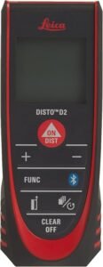
Laser distance meters have revolutionized measurement efficiency, especially in tough conditions. These tools deliver impressive accuracy, with some models achieving precision within 1/16-inch at distances up to 100 feet. Advanced models come packed with features like:
- Digital Pointfinder to aim accurately in bright sunlight
- Height profile measurement capabilities
- Integration with CAD software through mobile apps
Specific models address common outdoor challenges. To name just one example, the Leica Geosystems tools offer an effective range up to 330 feet and include a digital camera with 4x zoom and stronger laser power. Target plates and stable precision tripods help improve measurement accuracy over long distances.
Digital Revolution: Apps for Landscape Measurements
Mobile technology has revolutionized how landscape professionals measure properties. We tested measurement apps of all types and found the best ones that give precise and efficient results.
Top landscape measuring apps compared
Planimeter leads other landscape measuring software by using satellite imagery for inch-perfect measurements. Professionals can survey properties from anywhere and share their data with team members. Homeowners or pros can easily measure a property size online. iScape also stands out by creating digital yard models and works with both metric and imperial measurements.
SiteRecon combines multiple imagery sources, including:
- Leaf-off winter imagery to see through tree canopies
- Street-level views for ground’s point of view
- High-resolution aerial imagery for detailed measurements
Accuracy testing: Digital vs. traditional methods
GIS mapping results match visual assessment methods across all land types. Our tests showed digital tools were more accurate in complex scenarios. Of course, LiDAR scanning captures thousands of data points every second and gives unmatched precision even on tough terrain.
Digital measurement apps work better because they:
- Cut down human error through automated data collection
- Give consistent results no matter who uses them
- Let users measure remote or dangerous areas safely
Cost comparison and ROI analysis
Digital tools might cost more upfront, but their long-term benefits make them worth it. Our detailed analysis shows digital measurement solutions reduce estimation time by 90%. Better measurements lead to more accurate estimates that boost project profits.
ROI evaluation highlights these key metrics:
- Customer Acquisition Cost
- Customer Lifetime Value
- Conversion Rate
- Average Order Value
Teams should look for these key features in measurement apps to get the best returns:
- Live data analysis capabilities
- Customizable dashboards
- Multi-channel attribution
- Automated reporting functions
Without doubt, digital tools’ efficiency turns into real cost savings. Account managers save 95% of their time when they use automated takeoff software instead of old measurement methods. Teams can focus on building customer relationships and growing their business rather than taking manual measurements.
Modern apps’ integration features add even more value. Most professional tools now connect smoothly with CAD software, design programs, and project management systems. This makes the whole process flow better from first measurement to final design.
Despite taking time to learn, landscape professionals see major benefits when they switch to digital measurement tools. They get more accurate estimates and save lots of time during customer visits. Knowing how to generate instant calculations for areas and elevation changes makes these tools essential for modern landscape planning and execution.
Advanced Technology: Drone and GPS Tools
Drones and GPS technology have altered the map of the land measurement industry with their unmatched precision and speed. These advanced tools work better than old methods, especially on big projects.
Drone mapping capabilities for large properties
Fixed-wing drones do a great job mapping big areas and they last longer in the air. Our tests showed that drones with high-resolution cameras can take detailed aerial pictures in minutes instead of the hours needed for manual surveys. These devices can be accurate to within 2 centimeters, which makes them a great way to get precise measurements.
Today’s drones come packed with special features that improve their measuring abilities:
- Live 2D orthomosaic generation
- High-accuracy GPS integration
- LiDAR sensors that model terrain in detail
A drone needs just 10-15 minutes to survey a whole property with amazing detail. These flying tools help professionals figure out exact measurements of earth for excavation and grading, which speeds up project planning.
GPS-based measurement systems
GPS measurement systems have grown into highly accurate tools that can be precise to within 5 feet per mile. These systems track where vehicles go and map their GPS coordinates, which helps a lot with highway and sign inventory work.
The newest GPS measuring tools give you:
- Live location tracking
- Multiple measurement units (meters, feet, kilometers)
- User-friendly plotting tools
GPS-based systems shine because they let you measure areas from far away. Professionals use special software to work out distances, perimeters, and areas from GPS coordinates. This helps a lot when the terrain is tough or areas are off-limits.
When to invest in advanced technology
Your business needs should guide your choice to buy drone or GPS technology. To cite an instance, drone solutions work best for projects with:
- Large-scale property surveys
- Hard-to-reach locations
- Complex terrain analysis
You’ll see the payoff quickly – drone technology cuts estimation time by 90%. These tools also let teams handle multiple takeoffs at once, which speeds up work by a lot.
The data from drones blends naturally with design software like Civil 3D or LandFX. This connection helps professionals create 3D maps and models that show height differences between current and planned landscapes. So clients can see exactly how their project will turn out, even if they’re not at the site.
Motion-Based Measurement Tools: The New Standard
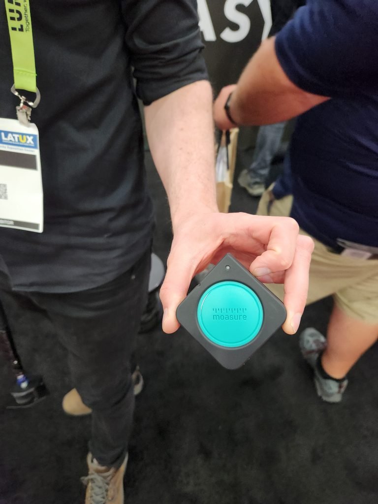
Motion-based measurement technology revolutionizes traditional landscape measuring tools. Advanced inertial sensors capture precise measurements through movement. This breakthrough eliminates the need for GPS signals or line-of-sight requirements. Moasure is the industry leading tool using this type of technology.
How motion measurement technology works
Motion-based measuring devices share technology with rocket guidance systems. These tools combine accelerometers and gyroscopes to track movement in three dimensions. The sensors take more than 500 measurements every second. The device calculates its position in 3D space by measuring:
- Distance and perimeter
- Area calculations
- Changes in elevation
- Grade and rise measurements
The device marks the first recorded point as the origin (X:0, Y:0, Z:0). Advanced algorithms compute overall linear distance and area based on subsequent coordinates relative to this starting position [43, 44].
Ground accuracy testing results
Field testing showed remarkable precision levels. A motion-based device measured a 235-foot perimeter with only a 1.8% margin of error in one controlled experiment. The latest generation of these tools reduces errors by up to 50% compared to earlier versions.
These factors affect measurement accuracy:
- Movement speed between points
- Device placement technique
- Rotation control
- Regular pausing intervals
Error increases over time rather than distance. Quick movements between measurement points produce more accurate results. The technology excels in complex environments where traditional tools struggle.
Learning curve and training requirements
Becoming skilled at using motion-based measurement tools requires a well-laid-out approach. The “Show, Do, Watch, Coach” process delivers the best results when followed consistently. Success depends on hands-on practice under ground conditions.
Users should master these three techniques to get optimal results:
- Pace: Walk quickly between measurement points
- Placement: Set the device down quickly yet gently
- Rotation: Turn the device gradually to protect sensor accuracy
Professionals who understand the technology can complete measurements in minutes instead of hours. The latest devices work for up to 10 hours continuously. This extended battery life supports lengthy projects.
The technology blends with design platforms like AutoCAD, Revit, and SketchUp. Measurements transfer instantly to digital design software. This streamlines the workflow from site survey to final design implementation.
AI-Powered Landscape Measuring Software
AI has altered the map of how landscape professionals measure properties. AI-powered tools now deliver pinpoint accuracy and better efficiency through machine learning algorithms and high-resolution satellite imagery.
Automated takeoff software explained
Modern AI measurement software can analyze satellite imagery and aerial drone footage to calculate property dimensions on its own. These tools process huge amounts of data through complex algorithms that identify property boundaries and features with amazing precision. The AI algorithms get into each pixel to generate accurate measurements.
The automation process has:
- Property boundary detection
- Area calculations for different surfaces
- Material quantity estimation
- Instant measurement reports
This technology cuts estimation time by 90%. Professionals don’t need to spend hours on manual measurements anymore. They just enter an address and get detailed takeoffs in their inbox.
Accuracy testing of AI measurements
AI-powered measurement tools have shown exceptional precision in controlled testing environments. The technology combines several data sources to ensure accuracy:
- High-resolution aerial imagery
- Street-level viewpoints
- Leaf-off winter views to improve visibility
Extensive testing has shown that AI measurements are much more precise. The system analyzes satellite images and provides exact measurements of property boundaries and features with minimal human error. Businesses that use AI measurement tools now measure all their jobs, up from previous rates of 60%.
Integration with design and estimation software
AI measurement tools merge naturally with existing landscape design and business management platforms. The software can:
- Export directly to CAD programs
- Calculate costs as they change
- Generate automated material quantity estimates
- Create instant proposals
These features streamline the workflow from the original measurement to final proposal. The technology helps professionals create optimized designs based on environmental conditions and client priorities. The software calculates resource requirements automatically to cut waste and optimize material usage.
AI-powered measurement tools have made a big difference in business operations. Companies report up to $100,000 in extra revenue per sales representative each year. Account managers save about 80% of the time they used to spend on measurements.
AI measurement technology keeps evolving. New developments focus on using up-to-the-minute data from IoT devices and weather monitoring systems to improve project planning accuracy. AR/VR technologies powered by AI will let clients see landscape designs as they’re created, which makes decision-making better.
Conclusion
Landscape measurement tools have evolved dramatically from simple tape measures to sophisticated AI-powered solutions. Our testing and real-life experience shows modern measurement technologies reduce estimation time by 90% and deliver better accuracy.
Traditional tools remain useful for specific tasks. Digital solutions now deliver exceptional efficiency. Motion-based devices and AI-powered software excel at providing precise measurements within minutes rather than hours. These tools merge with design software and streamline the workflow from original measurement to final implementation.
Your specific needs and project scope determine the right measurement tools. Small residential projects might need only simple tools. Large commercial properties get better results from drone mapping or GPS systems. Advanced measurement technology’s upfront cost yields returns through improved estimates, fewer errors, and substantial time savings.